logo
Home ProductsDoppler Wind Lidar

Vertical Range minus 10 to 190 degrees remote data collection tool featuring 4 kilometer vertical measuring distance tailored for industrial

Certification
china Nanjing Movelaser Co., Ltd. certification
Customer Reviews
I am very satisfied with the after-sales service attitude, the product quality is excellent, and I hope to continue to maintain it

—— Liyong Xiong

Your company's products have shown excellent performance and excellent quality during operation, providing strong support in scenarios such as early project wind measurement and operational project evaluation; Your team provides timely response, effective communication, and thoughtful service in equipment installation, maintenance.

—— Yunda Li

After the product finds problems, it can be quickly dealt with after the sale. It is recommended to make the product suitable for more environments。

—— Jiemin Fu

Overall I am very satisfied and hope to continue to provide us with more advanced, reliable and stable radar equipment.

—— Fan Yang

It is hoped that the products will continue to be optimized, updated and iterated, the quality will be more stable, and the service, delivery and after-sales will continue to maintain high quality, and achieve the industry-leading level.

—— Yuwei Wang

The delivery of the product, the processing of the equipment is very timely

—— Long Chen

Positive attitude of marketing personnel, timely after-sales service

—— Kai Zhao

Continue to work hard, win-win cooperation

—— Yuyan Xie

The equipment and service are very good, and I look forward to continuing cooperation in the future.

—— Mingjie Zhou

The equipment is easy to install and suitable for unit testing.

—— Luke Wang

The ground-based wind lidar has good performance and has been recognized by our internal and complete machine manufacturers, and there is no objection to the test results. The sales staff have extensive technical knowledge and professional answers. The on-site staff are active and look forward to cooperating again.

—— Kunpeng Lu

In the radar installation service, the marketing personnel have good attitude, strong technical ability, and solve problems in place, which provides a solid guarantee for the transportation and installation of lidar.

—— Liang Gao

This wind measurement system has completely transformed our data collection. The accuracy and stability are outstanding, even under harsh conditions. The technical support team is exceptionally professional!

—— James M.

Since deploying your LiDAR devices, our wind farm assessment efficiency has increased by at least 40%. It’s not only reliable but also user-friendly. Highly recommended to anyone in the field!

—— Sophia Chen

Outstanding precision and incredible durability! Our field stations have relied on this equipment long-term, and it has never let us down. A perfect blend of cutting-edge technology and practical design.

—— Ahmed Al-Farsi

As a researcher, I demand the highest data accuracy. This system has exceeded all expectations—its low power consumption and easy integration have significantly accelerated our project.

—— Elena Rossi

Stable, precise, and nearly maintenance-free—exactly the industrial-grade solution we needed. It has helped us optimize energy output while reducing operational costs substantially.

—— Tomás Herrera

From pre-sales consulting to technical training, the service experience has been impeccable. The equipment performs excellently and provides critical insights for our clients' wind energy projects.

—— Priya Sharma

We have tested several similar products, but this system stands out for its long-term stability and data consistency. It truly is the silent partner in environmental monitoring.

—— Björn Lundgren

I'm Online Chat Now

Vertical Range minus 10 to 190 degrees remote data collection tool featuring 4 kilometer vertical measuring distance tailored for industrial

Vertical Range minus 10 to 190 degrees remote data collection tool featuring 4 kilometer vertical measuring distance tailored for industrial

Large Image :  Vertical Range minus 10 to 190 degrees remote data collection tool featuring 4 kilometer vertical measuring distance tailored for industrial

Product Details:
Brand Name: MOVELASER
Model Number: 3D Scanning Doppler Wind Lidar Molas 3D
Payment & Shipping Terms:
Minimum Order Quantity: 1 Set
Packaging Details: Air Box
Delivery Time: 1-2 Months
Payment Terms: L/C, D/A, D/P, T/T
Supply Ability: 200 Set ,1 Month
Detailed Product Description
Size: 756mm*735mm*1000mm Sight Detection Distance: 10km
Maximum Acquisition Distance: 15km Distance Resolution: 15m/30m/75m/120m
Sight Wind Speed Accuracy: 0.1m/s Weight: ≤100kg
Pointing Acuracy: ±0.005° DataStorage Time: 5to18months
Highlight:

Doppler Wind Lidar remote data collection

,

Doppler Wind Lidar 4km measuring distance

,

Doppler Wind Lidar industrial vertical range

Product Description:

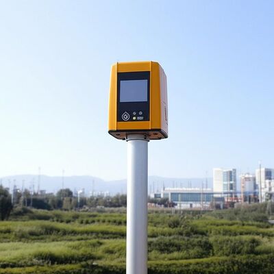
Molas 3D is an advanced Doppler wind measurement lidar that operates using three-dimensional scanning technology. It utilizes the principle of pulsed laser coherent Doppler frequency shift to accurately capture wind speed data.

This innovative device supports multiple scanning modes, including P-Pl, RHI, DBS, and program scanning. Such versatility allows it to be tailored for specific wind speed measurement requirements across various applications.

The Molas 3D lidar is well-suited for a wide range of customized scenarios. These include offshore wind resource assessment, research in complex terrains, wind turbine wake detection, and airport glide path wind shear warnings. Additionally, it is valuable for urban meteorological observations and detecting high-altitude turbulence.


Features:

Comprehensive Measurement Capabilities

The system offers detailed measurement information by utilizing a refined 3D wind field measurement technique. It supports up to 300 customizable distance layers, allowing for precise and tailored data acquisition.

Wide Detection Range

Equipped with a large detection range, the device can monitor sight distances up to 10 kilometers, particularly effective at altitudes below 600 meters.

High Accuracy Performance

This technology ensures exceptional precision, featuring a pointing accuracy of 0.005 degrees and a visual direction wind speed accuracy of 0.1 meters per second.

Diverse Scanning Methods

Multiple scanning techniques are supported, including PPl, RHl, DBS, and a programmable arbitrary scan method, allowing for versatile operational modes based on varying measurement needs.

Flexible and Lightweight Deployment

Designed to be small and lightweight, the system facilitates easy transportation and rapid deployment in different environments.

All-Weather Durability

Built to withstand harsh outdoor environments, it offers survivability in LPz0 and features lightning protection zones, ensuring reliable operation regardless of weather conditions.

Safety and Security Features

Safety is paramount, with integrated GPS location reporting and geo-fencing capabilities. Additionally, data encryption safeguards against any risk of information leakage.

Multiple Configuration Options

Users can select from four distance resolutions and five accumulation times, providing flexibility to tailor the system’s operation to specific requirements.


Technical Parameters:

Vertical Range -10~190°
Sight Detection Distance 10 km
Sight Wind Speed Range -75~+75 m/s
Distance Resolution 15 m / 30 m / 75 m / 120 m
Sight Wind Speed Accuracy 0.1 m/s
Distance Layers Up to 300
Pointing Accuracy ±0.005°
Accumulation Time 0.2~10 s (Optional)
Data Storage Time 5 to 18 months
Vertical Measuring Distance 4 km

Applications:

Wind resource assessment involves collecting wind field data over extensive areas, which helps to minimize the risks associated with site selection for wind energy projects. By accurately measuring wind parameters, it ensures better planning and utilization of wind resources.

Long-distance power curve measurements and wake eddy current assessments play a significant role in optimizing wind energy utilization. These measurements contribute to improving the efficiency of wind energy units by providing detailed insights into wind flow dynamics and turbine performance.

Early detection and warning systems are essential for identifying dangerous meteorological phenomena, such as wind shear and microbursts. Timely warnings can enhance safety measures in aviation and other weather-sensitive operations.

Measuring wake vortices is crucial for optimizing flight separation at airports. By understanding these vortices, air traffic controllers can better manage aircraft spacing, thereby increasing airport traffic efficiency and safety.

Providing detailed wind field information aids in understanding the behavior of wind within the atmospheric boundary layer. This data is vital for meteorological studies and improving weather forecasting models.

Accurate and high spatiotemporal wind profile measurements near the surface, within a few kilometers, help fill the observation gaps at low altitudes. This enhanced data resolution supports various applications ranging from environmental monitoring to renewable energy development.

Real-time three-dimensional information about plume dispersion enables effective tracking of emission sources. Such monitoring is particularly valuable for environmental management and controlling air pollution.

Additionally, optimizing dust emission control in the mining industry relies on precise wind and dispersion measurements. These techniques help minimize environmental impacts and enhance operational safety in mining activities.


Contact Details
Nanjing Movelaser Co., Ltd.

Contact Person: Miss. ivyyao

Tel: +86 13072523225

Fax: 86-025-86800073

Send your inquiry directly to us (0 / 3000)