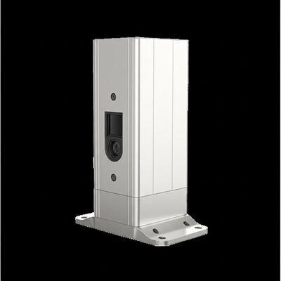
Product Description:
Molas 3D is an advanced Doppler wind measurement lidar system that operates using three-dimensional scanning technology. It is based on the principle of pulsed laser coherent Doppler frequency shift, which enables accurate detection of wind speed and direction in real time.
This sophisticated device supports multiple scanning modes, including P-Pl, RHl, DBS, and program scanning, providing versatile options for various applications. Its flexibility allows it to be tailored to meet the requirements of different wind measurement scenarios.
Molas 3D is especially suitable for specialized uses such as offshore wind resource assessment, studies in complex terrain, detection of wind turbine wakes, and airport glide path wind shear warnings. Additionally, it is effective for urban meteorological observations and high-altitude turbulence detection, making it a comprehensive tool for diverse environmental monitoring needs.
Features:
Rich Measurement Information
The system provides detailed three-dimensional wind field measurements with a refined resolution.
It supports up to 300 customizable distance layers, allowing for highly precise data collection.
Extensive Range
Equipped with a sight detection capability of up to 10 kilometers, the system effectively monitors areas beneath the height of 600 meters.
This ensures a broad and comprehensive observation coverage.
High Precision
The device achieves an exceptional pointing accuracy of 0.005°, accompanied by a visual direction wind speed accuracy of 0.1 meters per second.
Such precision guarantees reliable and accurate measurements in various operating conditions.
Various Scanning Methods
Multiple scanning modes are supported including PPI, RHI, DBS, and programmable arbitrary scan methods.
This flexibility allows users to tailor scanning patterns to specific applications and requirements.
Flexible Deployment
Designed to be compact and lightweight, the system can be easily relocated and installed in different environments.
This feature enhances its adaptability and convenience in the field.
All-Weather Durability
The equipment is built to withstand harsh outdoor conditions without compromising performance.
It features survivability compliant with LPz0 standards and includes protection against lightning strikes.
Safe to Use
Safety is ensured through integrated GPS location reporting and geo-fencing capabilities.
Additionally, data encryption measures effectively eliminate the risk of data leakage.
Multiple Configuration Options
Users can select from four different distance resolutions and five accumulation times, allowing for customizable operation suited to varying measurement needs.
Technical Parameters:
|
Sight Detection Distance
|
10 km
|
|
Vertical Range
|
-10~190°
|
|
Vertical Measuring Distance
|
4 km
|
|
Scanning Method
|
PPI, RHI, DBS and Program Scan
|
|
Distance Layers
|
Up to 300
|
|
Data Storage Time
|
5 to 18 months
|
|
Distance Resolution
|
15 m / 30 m / 75 m / 120 m
|
|
Data Output
|
Profibus DP / Modbus TCP / CAN Optional
|
|
Sight Wind Speed Range
|
-75~+75 m/s
|
|
Size
|
756 mm × 735 mm × 1000 mm
|
This wind lidar product is designed for remote sensing applications and is ideal for lidar rental solutions requiring advanced wind measurement capabilities.
Applications:
Wind resource assessment involves measuring wind field information over a large area, which helps to reduce the risk associated with site selection for wind energy projects. By accurately evaluating the potential wind resources, developers can make more informed decisions and improve the viability of wind farms.
Long-distance power curve measurements and wake eddy current measurements are essential for optimizing wind energy utilization. These techniques help to enhance the efficiency of wind turbines by reducing wake effects and improving overall unit performance.
Early detection and warning of dangerous meteorological phenomena, such as wind shear and microbursts, play a crucial role in safety. Monitoring these events enables timely alerts that can protect both aviation operations and ground activities.
Measuring wake vortices is also important for optimizing flight separation at airports. This allows for safer and more efficient management of air traffic by minimizing the risk of turbulence-related incidents.
Providing detailed wind field information helps to understand the state of wind within the atmospheric boundary layer. This data is vital for various meteorological and environmental studies.
High-accuracy, high spatiotemporal wind profile information within a few kilometers of the surface addresses a critical gap in low-altitude observations. Such precise measurements support better weather forecasting and environmental monitoring.
Real-time three-dimensional information on plume dispersion is used to track emission sources effectively. This capability is important for environmental protection and regulatory compliance.
Additionally, optimizing dust emission control in the mining industry relies on accurate wind data to minimize environmental impact. By monitoring dust dispersion patterns, mining operations can implement more effective mitigation strategies.

 Your message must be between 20-3,000 characters!